![[OMAO Banner]](https://omaopublicshare.blob.core.usgovcloudapi.net/seg-standard-images/StandardHeader/header-left.png)
![[Department of Commerce Tail Logo]](https://omaopublicshare.blob.core.usgovcloudapi.net/seg-standard-images/StandardHeader/header-right.png)
Overview
The NOAA Platform Awareness Dashboard (N-PAD) website is used to present NOAA and other government or military personnel with an overview of the current positions for all NOAA owned, operated or sponsored Aircraft, Ship, and Unmanned Maritime Systems.
This site is not meant to act as a data repository nor provide in depth analytics regarding the history, performance or mission of any platform. Various other sites (SDAT, ERDDAP, NCEI, etc) are available to fulfill those needs and overlap has been kept to a minimum.
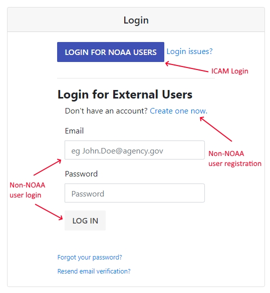
Logging into the system
Access to this system is restricted to those user with current valid government or military email addresses.
If you work for NOAA you must use the ICAM system to authenticate, no need to register or create an account.
If you do not work for NOAA then you must register using your *.gov or *.mil email address. A confirmation email will be sent to you which you must use to validate your registration prior to your account being enabled. If you do not receive the confirmation email you may request another be sent.
Logging out of the system

Understanding the map
The map is the main interface used to visualize the positions of the various assets.
Zooming

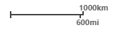
Scale Bar
Toolbar
In the upper left corner of the map you'll notice the "N-PAD Control Pane" which is your main interface to the map screen.
This control pane is a window which you can drag around the screen or collapse by clicking the "-" sign on the top right.
When accessing the site on a mobile device the control pane will initialized in a collapsed position to keep it out of your way due to limited screen size. To expand it click the "double window" icon which replaces the "-" sign.
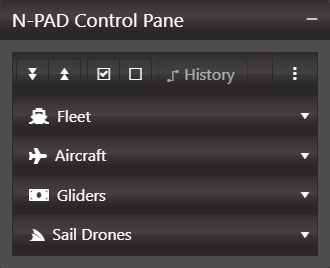
At the top of the control pane you'll notice a toolbar with various buttons.
-

Expand and Collapse Items
Clicking the button with the down arrows will expand all groups below.Clicking the button with the up arrows will collapse all groups below. -

Display all/none
Clicking the button with the checked checkbox will check all items and display everything on the map.Clicking the button with the unchecked checkbox will uncheck all items and clear everything from the map. -
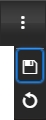
Persist / Save Checked Items
Clicking the dropdown (3 vertical dots) will show two options.Clicking the save button save your current selections to a cookie on your machine. The next time you visit the site (on that machine) your selected items will be re-selected.Clicking the reset button will clear your selections and return to the default state (everything selected) along with removing the cookie.
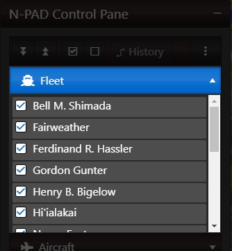
Show / Hide Tracked Items
Under the toolbar in the main control pane window there are groups of assets which are tracked by this website. These are mainly
- Fleet - The large NOAA Ships
- Aircraft - The large & small NOAA Aircraft
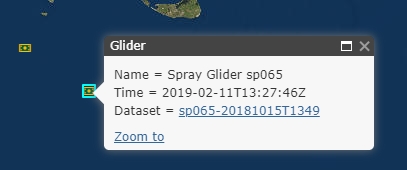
- Gliders - Wave Gliders mainly recorded via IOOS
- SailDrones - Sail Drones mainly recorded via PMEL
Each category of tracked item can be expanded by clicking on it (eg click "Fleet" to see the fleet items). Once expanded you can see all items which have recorded data within the last year for (or in coordination with/supported by) NOAA.
By default every item in each category is checked. When an item is checked it's latest reported position is displayed on the map. To hide/remove an item from the map simply uncheck it.
Attributions
-
Maps provided by ESRI ArcGIS Javascript libraries

-
Ship Data provided by NOAA Scientific Computer System

-
Aircraft Data provided by NOAA Aircraft Operations Center
-
Wave Glider Data provided via NOAA IOOS ERDDAP Server

-
Sail Drone Data provided via NOAA PMEL ERDDAP Server